A Voie Field Guide
Las Cruces &
The Mesilla Valley.
Organ Mountains · Old Mesilla · White Sands · Hatch · The Gila
Welcome to Las Cruces — a sun-drenched high desert town tucked between the granite spires of the Organ Mountains and the pecan groves of the Mesilla Valley. The chile roasts in autumn, the skies stay mostly blue, and some of the country's most unexpected landscapes — gypsum dunes, cliff dwellings, fossilized trackways — are an easy drive away.
A Las Cruces rite of passage. Rich frozen custard with pecans, green chile, or seasonal fruit.
Map →Southwest-meets-southern comfort food with an in-house brewery and a pecan-wood grill. The pecan-crusted chicken is the signature.
Map →The move for a fast, killer breakfast burrito smothered in Hatch green chile.
Map →The unofficial living room of Las Cruces. Strong espresso, homemade pastries, and a steady hum of students and locals.
Map →New Mexico craft beer and an elevated pub menu. The Pecos burger is the go-to.
Map →A Mesilla institution since 1939, inside a rambling 1840s adobe that was once a Butterfield Stagecoach stop. Red chile enchiladas, tableside margaritas, resident parrots.
Map →Fine dining in an 1849 territorial mansion on the plaza. Serious steaks, a famous Sunday champagne brunch, and a resident ghost.
Map →Beloved for its bustling salsa bar, handmade tortillas, and some of the best chile rellenos in the valley.
Map →Chef-driven bistro pairing New Mexican flavors with a global wine list. Tapas, seasonal small plates, cozy wine-bar vibes.
Map →The rebrand of the beloved St. Clair Winery, from New Mexico's largest family-owned winery. Reliably yummy plates, a beautiful patio, and sweeping Organ Mountain views. A favorite.
Map →A relaxed taproom with clean, crisp house beers, a dog-friendly patio, and rotating food trucks.
Map →A tiny, no-frills spot slinging iconic New Mexican plates since the 1960s. Come hungry, come early — the line is part of it.
Map →A longtime local favorite for from-scratch Italian — wood-fired pizzas, housemade pastas, warm-bread-basket energy.
Map →A warm, wood-fired neighborhood spot for hand-tossed pizzas, green chile burgers, and generous steaks.
Map →The closest full grocery, with a great fresh tortilla counter and solid produce.
Map →Organic produce, bulk bins, and a good beer and wine aisle.
Map →Local specialty grocer with a standout deli, a real butcher counter, an impressive wine shop, and prepared foods.
Map →Community-owned since 1976. Organic produce, local meats, good bulk section, and a small café in back.
Map →Fresh corn and flour tortillas made daily. Grab a dozen warm before dinner.
Map →One of the largest farmers markets in the Southwest. Saturdays and Wednesdays, 8:30am–1pm, on downtown's Main Street Plaza.
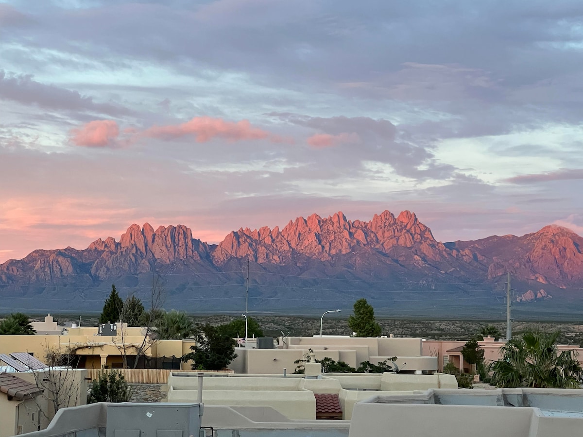
Map →The Organ Mountains rise straight out of the desert just east of both houses — jagged pink-granite spires that turn gold at sunset and define nearly every view in town.
Carry more water than you think you need — a gallon per person on any summer hike.
Sun is intense year-round. Sunscreen and a brimmed hat go a long way.
Monsoon storms roll in fast in July and August — avoid low-lying washes when it's raining in the mountains.
Evenings cool off quickly, even in summer. A light layer makes patio dinners better.
The main entry into the Organ Mountains–Desert Peaks National Monument. Excellent rangers at the visitor center. Road closes at sunset.
Map →Past the ruins of a Victorian mountain resort and a 1920s tuberculosis sanatorium to a seasonal spring.
A prehistoric rock shelter used by Native peoples for thousands of years. Big views, little effort.
The back side of the Organs, with sweeping views over the Tularosa Basin. One of the finest day hikes in southern NM.
A quieter canyon hike that climbs toward a seasonal waterfall. Spectacular in wildflower season (late March–April).
Map →The trailhead for the Pine Tree Loop, reached via US-70 east. Stunning at dusk; the road in is a worth-it narrow climb.
Map →The little volcanic hill east of town with a giant whitewashed "A" on its side. Quick sunrise/sunset loop with panoramic views of the city, the valley, and the Organs.
Map →300 cottonwood-shaded acres along the Rio Grande. Easy interpretive trails, excellent birding, and some of the best sunset light in the valley.
Map →280-million-year-old fossilized footprints of reptiles, amphibians, and insects on the Robledo Mountains. A rocky, moderate hike with real wow moments.
Map →The heart of historic Old Mesilla, where Billy the Kid was once sentenced to hang. Adobe galleries, leather shops, chile ristras, and the twin-steepled Basilica.
Map →The city's open-air gathering place. Public art, splash fountains for kids, Saturday farmers market, and a steady rotation of festivals.
Map →Rotating exhibitions with a strong regional contemporary focus. Free admission.
Map →1935 WPA-era adobe with rotating exhibits on Las Cruces and borderlands history.
Map →Small but well-done. Live Chihuahuan Desert animals, dinosaur fossils, a great kids' discovery area.
Map →A lovingly restored 1910 Santa Fe depot full of railroad history, model trains, and period artifacts. Free and kid-approved.
Map →An enormous, wonderfully chaotic used bookstore — 500,000+ titles. Easy to lose an afternoon.
Map →47 acres celebrating 4,000 years of farming in the region. Live animals, daily milking demos, blacksmithing. Surprisingly excellent for all ages.
Map →The Aggie campus is a lovely stroll, with public art, the NMSU Museum, and a steady calendar of gallery openings and Pan American Center shows.
Map →The shimmering, 275-square-mile gypsum dune field that looks like snow in the middle of the desert. Rent a sled at the visitor center and stay for sunset. Check ahead for missile range closures.
Map →A golden-cube museum built into the Sacramento foothills, honoring the state's role in the Space Age. Pair with White Sands for a full day.
Map →Alpine air, ponderosa pines, and a charming village at 7,000 feet. Ski in winter, hike and ride in summer.
Map →A tiny farming village where every business revolves around green chile. Stop at Sparky's for a world-famous green chile cheeseburger, then pick up ristras and ground chile to take home.
Map →The world's first purpose-built commercial spaceport. Tours are reservation-only and leave from T or C.
Map →A surreal, 34.9-million-year-old volcanic formation of house-sized pinnacles you can scramble through. Excellent stargazing.
Map →An artsy former mining town in the Gila National Forest with great galleries, coffee shops, and some of the best hiking in New Mexico nearby.
Map →700-year-old Mogollon cliff dwellings in a narrow canyon deep in the Gila Wilderness. The drive in is long, winding, and spectacular. Plan for a full day.
Map →45 minutes south. The Chamizal National Memorial, the Franklin Mountains, Hueco Tanks rock art, and some of the best Mexican food in the country.
Map →The Mesilla Valley is part of the oldest wine-producing region in the United States — roots dating back to 1629, nearly 150 years before California. Most tasting rooms are small and family-run; hours can be seasonal, so call ahead.
A beautiful family-run tasting room with big Organ Mountain views from the patio. Especially nice at sunset. Known for dry whites and their signature estate Viognier.
Map →Formerly St. Clair. Reliably yummy food, beautiful patio, sweeping Organ Mountain views. One of our favorites (also in Food + Drink).
Map →The Calvi family's tasting room paired with a wood-fired pizzeria. Estate wines from their Deming vineyards and solid pies — an easy weeknight stop.
Map →New Mexico's oldest winery, tucked into the pecan orchards south of Las Cruces. Tastings on a shaded patio and live music on weekends. Worth the drive.
Map →
A modern, light-filled home with sweeping Organ Mountain views, a jetted tub, and all the quiet of the foothills.

A bright, dog-welcoming modern adobe — Peloton in the home, room for the family, and easy access to the Organs and Old Mesilla.
Written from the valley. Last updated April 2026.